Case Study No. 46
Leland Street Redesign
Bethesda, Montgomery County, Maryland
Prepared by Robert J. Schneider, Sprinkle Consulting, Inc. (SCI). Information provided by David A. Loughery, Montgomery County, Maryland Public Works and Transportation.
Problem
High vehicle speeds posed a safety hazard for local residents and pedestrians on an arterial roadway located in a densely settled inner-ring suburb populated primarily by single family homes with driveways.
Background
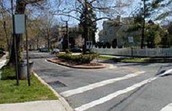
Gateway island at intersection.
Leland Street is an arterial roadway with closely concentrated residential frontage less than 0.5 mi from the Bethesda Metro Station outside of Washington, District of Columbia. Leland Street serves as a backdoor to Bethesda, an access route between Woodmont Avenue and Bradley Boulevard, two busy commercial streets. While the average daily traffic is not high on Leland Street (approximately 1200-2000), prior to its redesign in 1999, the street had experienced problems with excessive motor vehicle speeds. Although the posted speed limit is 25 mi/h, vehicles frequently traveled down the street in excess of 35 mi/h. Residents often experienced difficulty backing cars out of their driveways and walking across the street. Pedestrians traveling along both Woodmont Avenue and Bradley Boulevard to access the transit station and downtown Bethesda, faced a dangerous crossing at the Leland Street intersections.
When a new eight-story apartment building was proposed on nearby Woodmont Avenue the potential increase in traffic along Leland Street gave neighborhood residents an opportunity to raise their concerns about pedestrian and traffic safety. A series of meetings allowed residents, the developer, the Maryland-National Capital Park and Planning Commission, and the Montgomery County Department of Public Works and Transportation to begin working together to reduce traffic speeds and improve the safety of the street.
Solution
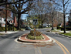
Chicane with median island creating serpentine design.
Residents initially requested speed humps, but Montgomery County policy prohibits humps on arterials. This obstacle led designers to a more creative alternative. Five center traffic islands, two serving as gateways at Woodmont Avenue and Bradley Boulevard, and six curb extensions were constructed to create a serpentine traffic flow along the street. At the intersection of Leland Street and Woodmont Avenue, the curb radius was reduced from 50 ft to 30 ft to slow vehicles making right turns from Woodmont Avenue onto Leland Street. This also shortened the crosswalk distance at the Leland Street intersection for pedestrians walking along Woodmont Avenue. The curb radius reduction was complemented by the center island gateway to Leland Street, ensuring that right-turning vehicles did not swing wide to make a faster turn into the street.
According to David Loughery of Montgomery County Department of Public Works and Transportation, the county's primary strategy was to reduce turning speeds onto Leland and reinforce slower speeds with a serpentine traffic flow: "If you can get vehicles to enter the street slowly, safe speeds can be maintained along the street."
The project, which cost around $40,000, would not have been possible without the help of several different groups. Residents talked to the developer who agreed to fund construction of the improvements and landscaping. The Montgomery County Department of Permitting Services created the design and pulled the major players together to streamline the implementation process. The County provided a contractor to reconstruct the street and retained turning restrictions during peak hours. The residents arranged for delivery of the landscape plantings and materials for the islands, planted them, and continue to maintain the plants and shrubbery.
Results
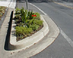
Curb extension.
The redesigned street resulted in slower speeds and safer conditions for pedestrians walking along the street and crossing at the intersections of Leland Street with Woodmont Avenue and Bradley Boulevard. Before and after traffic speed studies showed that the highest speed was lowered from 44 to 38 mi/h, 85th percentile speed was reduced from 32 to 27 mi/h, and mean speed dropped from 30 to 24 mi/h. Because traffic volume was not determined to be a critical element in the safety evaluation and decision process, full before and after ADT counts were not generated for the project. Two one-day, peak-hour counts were taken to confirm the low volumes.
Prior to the project, approximately 60 households, or over two-thirds of the neighborhood, signed a petition in support of the design. Opponents of the design were concerned about loss of parking and obstructing emergency vehicles, but only one resident complained openly about the project after it was completed. Constant feedback from the neighborhood during the design process resulted in a design that is supported by residents and will not require expensive retrofitting.
Keys to the success of this project were good street design and community partnership. The design used a combination of traffic calming measures to slow traffic at the entry points. The partnership included residents, a developer, and two public agencies working together in every phase from planning to design and throughout construction. In the end, traffic speeds were reduced to levels more appropriate for a residential community, safety was enhanced for motorists and pedestrians, and the streetscape was improved with no negative impacts on traffic operations.
Contact
David A. Loughery
Transportation Systems Safety Manager
Montgomery County Department of Public Works
and Transportation
101 Monroe Street, 10th Floor
Rockville, MD 20850
Phone: (240) 777-7161
Email: dave.loughery@co.mo.md.us
http://www.montgomerycountymd.gov/dot/index.html